
In our series “Maps and mappers of the 2016 calendar” we will present throughout 2016 the mapmakers who submitted their creations for inclusion in the 2016 GeoHipster calendar.
***
Andrew Zolnai
Q: Tell us about yourself.
A: I’m a geologist who turned to computer mapping 30 years ago and GIS 20 yrs ago – high school Latin helped me transition to coding just short of programming – and I now started my third business and assisted two others. I’m taking a ‘business process first’ approach, using mind mapping as a ‘talking point’ to help firms help themselves, which will determine workflows in resources planning that may invoke web maps. My Volunteered Geographic Information also helps individuals and academics put themselves on the map.
Q: Tell us the story behind your map (what inspired you to make it, what did you learn while making it, or any other aspects of the map or its creation you would like people to know).
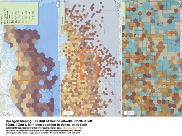
A: Ken Field’s hexagon maps featured on the BBC during UK elections this spring inspired me to do the same in the US Gulf of Mexico: 50K oil wells taxed arcgis.com, so binning the data points allowed to show progressively more detail at large scales as you zoom in. It clearly shows for example the march of wells further offshore with time, in a way that speaks to stakeholders and public as well as engineers and mappers.
Q: Tell us about the tools, data, etc., you used to make the map.
A: Esri ArcGIS for Desktop Standard and Model Builder, scripts adapted from Esri’s Ken Field for US Gulf of Mexico wells, posted on ArcGIS Online.
Comments
One response to “Maps and mappers of the 2016 calendar: Andrew Zolnai”
Thanks, here’s a bloggage update http://bit.ly/1UyhTmX