
In our series “Maps and mappers of the 2016 calendar” we will present throughout 2016 the mapmakers who submitted their creations for inclusion in the 2016 GeoHipster calendar.
***
Mario Nowak
Q: Tell us about yourself.
A: I studied geography at the University of Zurich, Switzerland, and did a Master in Geographic Information Science. I also studied land-use planning at ETH Zurich. Now I’m working for sotomo, a company based in Zurich specializing in political surveys, data journalism, and data visualization.
Q: Tell us the story behind your map (what inspired you to make it, what did you learn while making it, or any other aspects of the map or its creation you would like people to know).
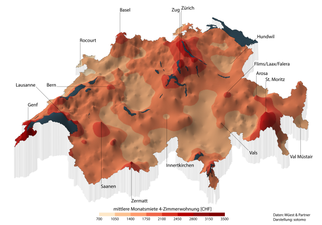
A: The map shows the rental prices for a flat in every municipality in Switzerland. We did this map on assignment for the Swiss newspaper Tages-Anzeiger. They used it for an article on rental prices in Switzerland.
It is the remake of a similar map my boss made in the nineties, but with newer data. In fact, this map is an animated map (see here): The temporal dimension is perceptible in the GIF version. The map also hints at the fact that Switzerland is a country of mountains, but in this map, the highest peaks are where the prices are the highest.
Q: Tell us about the tools, data, etc., you used to make the map.
A: The data comes from Wüest & Partner. It has a price value for every municipality (around 2,500[CHF]) for every year from 2000 to 2015. I only needed to extract the centroid of each municipality from a shapefile (done in QGIS) and match it to the data.
The map was then completely done in R. Two packages were particularly important: automap with its autokrige function, and the package plot3d (and the PDF file 50 ways to draw a volcano).
I did a lot of kriging interpolations to get a smooth surface. I also did linear interpolations between every time-step to make the growing of the mountains smooth. Otherwise, the GIF would have consisted of only 15 images. Finally, I produced high resolution raster image files and stitched them together using a tool called GIF animator.
Of course, there was a lot of trial and error involved in making this map, but now I am quite pleased with the result. It was, by the way, also nominated for the German reporter prize (however, it did not win 😉 ).
Comments
2 responses to “Maps and mappers of the 2016 calendar: Mario Nowak”
[…] http://www.geohipster.com/2016/02/01/maps-and-mappers-of-the-2016-calendar-mario-nowak/ […]
Congrats Mario!