
Sending off the year 2015, we present to our readers the mapmakers who contributed their work to the 2015 GeoHipster calendar.
***
Markus Mayr
Q: Tell us about yourself.
A: I’m a University Assistant at the Technical University of Vienna in Austria at the department of Geodesy and Geoinformation. But more than that, I’m an OpenStreetMap contributor and GIS nerd that can not decide whether it is more exciting to do JavaScript mobile programming or Python based backends. So, instead, I sometimes end up doing cartography with OpenSource tools.
Q: Tell us the story behind your map (what inspired you to make it, what did you learn while making it, or any other aspects of the map or its creation you would like people to know).
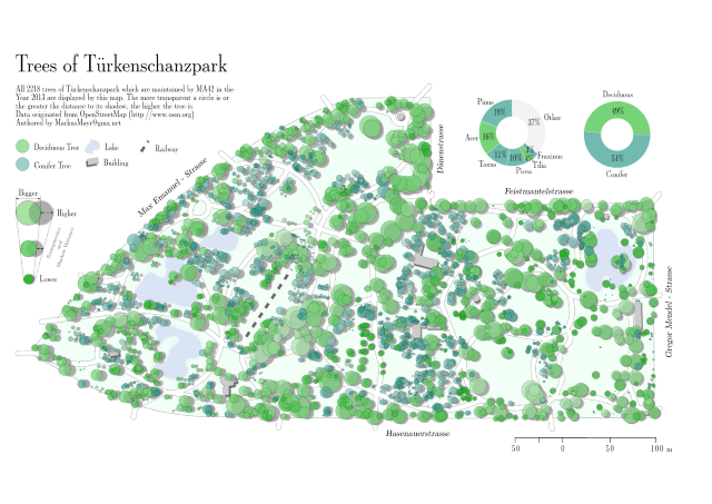
A: One lecture of the bachelor study program “Landscape Architecture and Landscape Planning” at the University of Life Sciences and Natural Resources (also in Vienna) is about learning trees — lots and lots of different trees. To make it more practical, the students walk around in the nearby Türkenschanzpark and study the different characteristics of the trees planted there. About 8 years ago, I was one of these students. One semester of learning how an e.g. one-year-old Juglans regia looks (and tastes) like left a lasting impression with me.
When data about all these trees became publicly available, it became of great interest to me. Still remembering the days of searching for one specific tree in the park, I started drafting a map…
Q: Tell us about the tools, data, etc., you used to make the map.
A: The map was composed using only open source software and data from freely available sources. Since the cadastre of trees of Vienna was imported into the OpenStreetMap some time ago, I was able to use solely data from OSM for this map.
The base layout and main cartographic work was done using QGIS. The map then was exported as a vector file and post-processed in Inkscape. While a lot of cartographic work can already be done within QGIS, some cartographic details just have to be crafted manually (e.g. the smoothing of the walking paths, more precise labelling, or slight generalization of the few buildings). (a hooray for traditional cartographers 😉 )
Inkscape proved to be up to the job — despite the slightly sluggish performance because of the many elements on display. The possibility to search for similar elements via XML-SVG attributes was a powerful feature that helped me a lot. Maybe, at some point in the future, Inkscape will be extended by a set of cartography tools?
Comments
4 responses to “13 maps in 13 days: Markus Mayr”
[…] http://www.geohipster.com/2015/12/28/13-maps-in-13-days-markus-mayr/ […]
Please give us a larger image. This one is impossible to read. Interesting series of posts, though, thanks.
Hi-res map on author’s website
http://gisforge.com/agency/
[…] Markus Mayr answers the question: Why tree imports? To produce beautiful maps. […]