

A former archaeologist, Kurt Menke (@geomenke) runs Bird’s Eye View GIS and is based out of Albuquerque, New Mexico. He works mainly in ecological conservation, public health, and education. He has been an avid open source GIS proponent ever since he made the switch from ArcIMS to MapServer back in 2002. He recently authored the 2nd edition of “Mastering QGIS” for Packt Publishing, and “Discover QGIS” for Locate Press. He is also an OSGeo Charter Member. In his spare time he enjoys big wild spaces, mountains, vinyl records, and good coffee.
Kurt was interviewed for GeoHipster by Randal Hale.
Q: Kurt Menke, where are you located and what do you do?
A: I live in Albuquerque, New Mexico which, contrary to what you often hear reported, is actually located in the United States. I run my own consulting business, Bird’s Eye View, and have worked at home since 2008. I consider myself a GIS generalist. I have been doing GIS for almost 20 years so “what I do” has changed over several times. I’ve built desktop and web mapping applications, developed data, conducted spatial analyses, and created maps. My mission is to help solve the world’s mounting ecological and social problems using GIS technology. Basically I want to use this technology to make the world a better place. My bread and butter is spatial analysis and cartography. Some of my favorite work involves modeling wildlife habitat and wildlife corridors. Many of my clients are non-profit conservation organizations in the western US.
I also do some work related to public health, and I’ve been involved in education and training for a while too. I’m a big fan of open source software and in 2010 I developed a full semester course called “Introduction to Open Source GIS and Web Mapping”. I usually teach it in the summer at my local community college. It’s now a required course there. I also was one of the major contributors to the GeoAcademy curriculum. That effort lead to me being an author. In the last two years I’ve authored “Discover QGIS” and co-authored two editions of “Mastering QGIS”. I’d like to get more involved in showing organizations how to migrate to FOSS4G.
Q: On LinkedIn you’re listed as a former archaeologist. What brought you into that field? How did you make your way from that into GIS?
A: I grew up in the suburbs of DC and started out at the University of Maryland where I picked Anthropology as my major. I eventually transferred to the University of New Mexico, partly because it had a great Anthropology program, but mostly to get away from home and have an adventure. I’ve been here ever since. After graduating I started working as a contract archaeologist. I did that for 8 years. It was a fun way to spend my 20s, but it’s hard work, and you end up collecting a lot of unemployment between gigs. It got to the point where I was ready to get a ‘real job’ instead of being a shovel bum. Some kind of synergy happened. I had a boss who was into remote sensing, which I’d never heard of, but it sounded cool. I’d always loved maps. I had a huge collection of paper USGS topo quads. He convinced me to enroll in the Geography Master’s program at UNM.
At the time I was completely computer illiterate. It sounds strange now, but it was still pretty common in the mid 90s. I ended up getting a job at the Earth Data Analysis Center at UNM, which is a GIS/Remote Sensing business that runs out of the university. It was there that I really cut my teeth on GIS. The first computer I used was a UNIX workstation through a terminal. We ran Arc/Info 7 and I loved it. It was all command line and I got really good at it. I ended up working at EDAC for 10 years. It was also there that I was first exposed to open source GIS. I did a lot of work developing web applications with MapServer, GRASS and PostGIS. Now I call myself a reformed archaeologist.
Q: What is a wildlife corridor and how hard are they to model? What tools do you use to do that?
A: Those are big questions. I’ll try to summarize. Wildlife have a home range or an area where they operate on the landscape. They also need to migrate occasionally. This might happen to find new food sources, better breeding grounds, or might be part of seasonal movements. A wildlife corridor is a route an animal uses to get from A to B. They also get called linkages or connectivity areas.
I think the ‘why they need to be modeled’ is important here. Wildlife habitats are becoming increasingly fragmented by human development, and habitat patches are becoming smaller. This has likely caused wildlife-vehicle collisions to increase. If a corridor can be accurately identified, people can work with transportation departments to build overpasses or underpasses for wildlife. It’s a win-win because it makes the road safer for people and removes barriers for wildlife movement.
There is also scientific consensus that the long-term survival of many species is dependent on protecting wildlife corridors. This is especially true for big animals with big home ranges, like mountain lions, elk, wolves, pronghorn antelope, etc. There’s the theory of island biogeography, which essentially states that the smaller an island, the fewer species it can support and vice versa. This is a universal ecological pattern found in the world. Fragmented habitat is like a small island.
They are hard to model, and this is just because the world is complicated and our understanding of how critters operate is incomplete. Corridors look very different from species to species. For example, a desert tortoise is not going to move like an elk. From a data perspective, you have to know a lot about the species, and you have to be able to represent things that are important to the species in a GIS. The first step is identifying where the habitat is. This usually involves a raster analysis, unless someone has already produced a good model for your area, but that just never seems to be the case. Variables usually include elevation, vegetation, hydrology and human impacts.
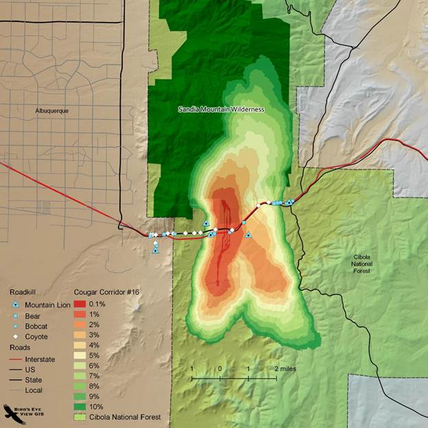
The next step is developing a resistance raster that represents ease of movement across the landscape. You can simply work off the idea that it is easier for a critter to move through good habitat than bad. So resistance is the inverse of habitat. Sometimes though people will develop a custom resistance surface if they know a lot about the animal. It likely includes a lot of the same variables in the habitat model but weighted differently.
From there it’s common to use some sort of least cost path tools. However, least cost paths are only one pixel wide which probably doesn’t represent reality so well. There is a nice tool in ArcGIS named Corridor that sums the cost and allows you to extract a swath of pixels as the corridor. Corridor Designer is one of the first tools I used. It was/is an ArcGIS toolbox with a suite of tools for modeling corridors using this approach. It probably doesn’t run so well on new versions of ArcGIS, but it was really handy. The coolest new tool is the open source Circuitscape. You essentially provide the habitat polygons and a resistance surface, and it outputs a connectivity raster for the entire study area. Of course this can all be scripted as well. I know there’s a package for R called Grainscape I’d like to check out.
Climate change is disrupting some of these patterns which throws a wrench into the works. People are now working on potential range shift models. Where will lynx habitat be in 2100 and where will the corridors be?
Q: I’ve seen your blog postings on community Health Maps. How much “GIS” is in the health field? It appears you’re doing workshops for people who are on a very limited budget.
A: This is a project I’ve been working on for a while. Community Health maps is a project of the National Library of Medicine, an agency I’d never heard of until I got involved. The goal is to empower public health organizations, working with underserved and at risk populations, with mapping technology. So yeah, our target audience is not GIS professionals, but public health workers. For the most part they are not computer savvy, but really need some basic geospatial tech. I teach half-day workshops where they learn how to 1) use Fulcrum to map their communities with smartphones, 2) map that data with CARTO, and 3) go even further with QGIS. The most gratifying aspect of these workshops is seeing people shed their technological insecurities. It’s common for people to show up and admit they’re scared of the technology. To then see in a few short hours, they are getting it all to work, and actually getting excited about the possibilities, is a beautiful thing. I also moderate a blog and have produced some related lab exercises. Overall I don’t think the health field is benefitting from geospatial tech nearly as much as they could. There are big programs at agencies like the CDC, but that isn’t really helping the typical public health worker in their day-to-day work.
Q: I’ve interviewed a few authors — and you mentioned Discover QGIS and Mastering QGIS — how hard is it to keep books on QGIS up to date? The QGIS developers have a quick release schedule and I imagine it’s easy to get far behind.
A: It’s hard. First of all, if all goes as planned, it takes a good 6 months from the start of the publishing contract to the end of the editorial process. During that six months, QGIS will have undergone at least one version change and is halfway to the next. Once out, the book is ideally current with the latest LTR for a year. As an example, we planned on getting the second edition of “Mastering QGIS” out in March of 2016 to coincide with the release of QGIS LTR 2.14. All our copy was complete by then, but due to issues with the publisher it wasn’t published until September. In a normal cycle that’s halfway through the book’s relevancy. I’m now considering updating “Discover QGIS” for the release of QGIS v 3.0. That book has over 700 screenshots, most of which will need to be updated. Then there’s accounting for all the great new features. It’s a daunting prospect. I want it done, but don’t want to do it.
Q: For me work/life balance is hard. What do you do for fun? I’ve seen on a year-end blog post you lift weights? You hike?
A: It is for me too, but it’s getting better. I really try to quit work at 5pm. Since I work at home, that routine is important to my overall sanity. As I was getting ready to leave the university and start my business, I spent a few years essentially working two jobs. It took a toll. The body really wasn’t meant to sit 50-60 hours a week. I started gaining weight and having problems with my elbows and wrists. Eventually I got an adjustable height desk which has helped.
I do lift weights. A few years ago my wife and I started really cleaning up our diet and working out with a trainer. He’s got his own little private gym. It’s just us and a few others. Now we lift weights 3 nights a week and do some sort of cardio on the weekend. It’s a blast, plus most of the aches and pains associated with being a desk jockey have gone. Workouts are also usually in the evenings so they get me to stop work on time. It’s my favorite part of the week. We’ve both gotten pretty fit. This winter I set two weightlifting PRs. I was most proud of back-squatting 315!
I also love hiking. I spend a lot of time up in the Sandia Wilderness outside of Albuquerque. One of my hobbies is climbing 14-ers (peaks over 14,000’). I’ve climbed 23 of the 54 in Colorado, and another 3 in California. I like backpacking too. A while back I hiked across Oregon on the Pacific Crest Trail. My buddy and I covered 500 miles in 40 days. It was an amazing experience. I can’t imagine being able to take that much time off now.

During the week, after work and working out, I can usually be found on the couch watching any one of the great TV shows out these days. I also love vintage film noir. The movies relax me. I listen to a ton of podcasts too. Lately I’m into S-Town, Criminal, Monday Morning Podcast (Bill Burr), Crime Writers On…, I Brew My Own Coffee, WTF with Marc Maron, and recently Hangouts with James Fee.
Q: How bad is the coffee addiction? It seems like it may be a problem.
A: Ha! It’s pretty bad, but what do they say? Admitting it is the first step. I’ve always loved coffee. A few years ago I started getting bummed that what I brewed at home wasn’t anywhere near as good as what the local coffee joints were serving. So I did some research and invested in a decent burr grinder, a scale, and a Chemex. Give Chemex a goog if you don’t know what one is. It was a game changer. I threw out my drip machine.

With the Community Health Maps project I’ve been traveling a lot. So I’ve started checking out the best coffee shops wherever I go to see what they have going on. That lead to getting into all the single origin coffees coming out. From there I started buying other brewers like an AeroPress, Kalita Wave, siphon, Moka pot, V60 etc. They’re all really affordable. Then I found a vintage Swiss espresso machine in my father in law’s garage. He didn’t want it, so I sent it out to be refurbished. That was expensive.
Anyway now I pretty much have a state of the art coffee shop in my kitchen. I’ve turned into a total coffee geek and I’m ok with it. I even bring an AeroPress and a portable hand grinder with me on trips to places without good local coffee. I can brew up great coffee in my hotel room.
Q: Almost 4 years ago we defined the geohipster to be a person who lives on the outskirts of mainstream GIS. So I’m reading back through this and we’ve got the makings of a geohipster. Do you feel like one?
A: What is it The Stranger says, “that’s a name no one would self-apply where I come from.” That’s where I am with it. I think in some respects I operate on the outskirts of mainstream GIS (ahem I meant the geospatial industry) and in others probably not. I’d love to be considered a geohipster, who wouldn’t, but I’ll leave that to others to decide.
Q: I leave the last question up to you: Anything you wish to tell the GeoHipster readers.
A: GIS and geo are simply ever-evolving tools for turning data into information. For me the application and the data are more important than the actual tools used. Mainly because every 5 or 10 years the tools completely change. Don’t get me wrong, that’s part of what keeps the job interesting day to day, learning new tools, but it’s the applications that can have a lasting impact.
Comments
One response to “Kurt Menke: “The most gratifying aspect of teaching these workshops is seeing people shed their technological insecurities””
[…] http://www.geohipster.com/2017/04/25/kurt-menke-gratifying-aspect-teaching-workshops-seeing-people-shed-… […]